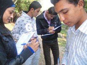
Sixteen young people from eight Jordan Valley communities took their first steps along the road to developing greater environmental awareness recently, when they participated in a Friends of the Earth Middle East (FoEME) community Geographic Information System (GIS) youth course.
Held at the Sharhabil bin Hassneh EcoPark, the course gave 16 students from years nine to 12 the opportunity to develop new skills in GIS hazard mapping, with the aid of an expert from the Jordan Geologists Association.
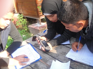
Students learned how to identify and categorize different environmental hazards by viewing photos and organizing information in a questionnaire. Then, using GPS devices, the students practiced plotting different hazard points at the ecopark,
FoEME’s Good Water Neighbors Project Youth Coordinator Lisa Kawar said these maps were important tools for communities to lobby local authorities for greater environmental conservation activities.
“The work these students are doing with the hazard mapping is very important for their communities, because these maps can then be shown to municipalities and relevant authorities to demonstrate not just where the environmental hazards are, but also give an idea of what needs to be done to avoid further damage to groundwater and ecosystems,” Lisa said.
The course was also an opportunity to build students‘ confidence as leaders and environmental educators.
“During the week between the two training sessions at the ecopark, the students have been asked to go back to their communities, tutor two to four peers about GIS, GPS, and identifying environmental hazards, and fill in a questionnaire. which will be used in the second session of the course to create their hazard maps,” and she continued.
“This has given them a chance to develop their leadership skills, and learn about how to pass environmental awareness onto others.”
She felt the course had been beneficial to the young people, and looked forward to engaging more students in environmental awareness activities through the hazard mapping.
“It has been a great opportunity for the students – they were able to interact with young people from other communities, and experiment with new technology in order to learn more about the environment,” she said.
Follow these links for more information about FoEME’s Good Water Neighbors community GIS projects, or the Sharhabil bin Hassneh EcoPark .
This blog was written by FoEME intern Lauren Salathiel, who is based in the Amman office.