On February 11th, FoEME staff, field researchers, UNESCO experts and local environmentalist came together to discuss and get to know the unique cultural heritage landscape of the Palestinian village Battir. The activist tour was led by members of the Battir Landscape Ecomuseum Project.
 Photo 1: FoEME staff and local activists
Battir, a Palestinian village in Bethlehem Governorate is located about eight kilometers to the south-west of Jerusalem. In the past this area was known as “the basket of vegetables”. In 2011, Batir’s council won the Melina Mercouri International Prize for the Safeguarding and Management of Cultural Landscapes. The system of irrigated terraces -with its Roman channels of irrigation- played an important role in the economic life of the area.
 Photo 2: Roman channels of irrigation
During the Ottoman period in 1890, the Ottoman administration built a railway line not far from the footpath. The “basket” got connected directly with Jerusalem and Jaffa. The new station, situated at the bottom of the Battir valley, provided an important element of change in the mobility of the inhabitants of the village and its surrounding areas, attracting the farmers from the other sub-districts in the Jerusalem and Bethlehem zones. The construction of the railway and the connection to the main centres of the Arab world –Cairo, Damascus, Beirut, Mecca– gave the opportunity for travel and for entering study and commerce in the major Arab sites of culture.
 Photo 3: Railway on the Green Line
But immediately after 1948, a process of fragmentation began to afflict the area of Battir and the surrounding villages situated south-east of Jerusalem. After the Rhodes agreement of 1949 between Jordan and the first Israeli government and the UN the Ottoman railway was renovated by the Israeli state administration, which subsequently decided to close the station of Battir and effectively eliminate the village’s railway stop, preventing the local inhabitants from using the train.
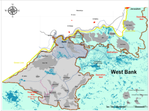
In the early 2000s, the Government of Israel started building the “Separation Wall”, which actually surrounds the Bethlehem urban area and isolates Battir and Western villages from the city of Bethlehem, affecting the Western villages and their connection to Bethlehem infrastructures and services.
In the last six years the Israeli Ministry of Defense and the Municipality of Jerusalem approved a plan for the construction of a new settlement in the territory of Al Walajeh and Battir. It foresees at least 14,000 Housing units, determining a huge impact, destroying the historical landscape and territorial system of Wadi al-Makhrour, one of the most valuable areas of the property in terms of cultural landscape.
FoEME staff, environmentalists and local people are working to reinforce the capacity of local authorities and stakeholders in the field of natural and cultural landscape management and of participated governance through the development of a model of sustainable use of the territory and to stop the destruction of the cultural landscape.
This post was written by FoEME intern Lena Siedentopp. Lena is based in FoEME’s Bethlehem office.
